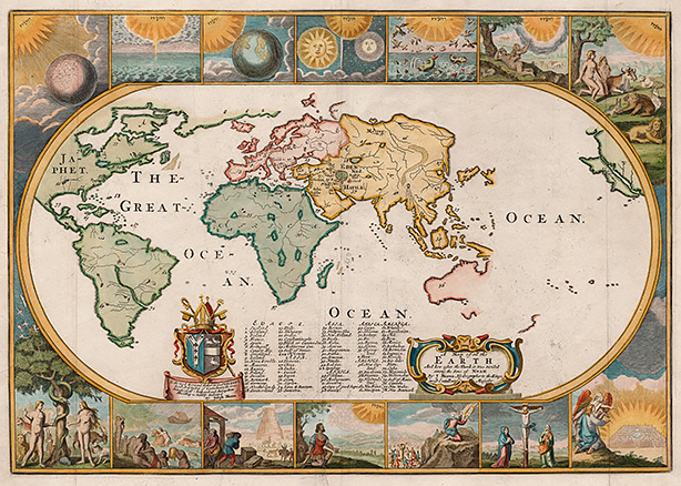
"A Map of the Earth and How After the Flood It Was Divided Under the Sons of Noah," from 1681, casts Christian history geographically, with Eden at its center. The map is one of about 300 in the new PJ Mode Collection of Persuasive Cartography at Cornell University Library. Image: Division of Rare and Manuscript Collections.
Maps with an agenda: Alum donates 'persuasive cartography' collection to library
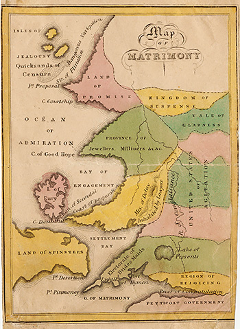
This 1827 "Map of Matrimony" by John de Peyster Douw includes provinces the Kingdom of Suspense, the Land of Spinsters and the Vale of Gladness. Image: Division of Rare and Manuscript Collections.
Using the "Map of Matrimony"? Navigate with care.
Its pastel-colored provinces encompass the Kingdom of Suspense, the Land of Spinsters and the Vale of Gladness. Its waterways range from the Ocean of Admiration to the Bay of Engagement. Beware the Isles of Jealousy, the Quicksands of Censure and the dangerous Straits of Flirtation.
At first glance, it looks like any other map. But it doesn't offer directions -- or an objective view of reality.
Rather, the 1827 "Map of Matrimony" and the 300 maps in the recently digitized PJ Mode Collection of Persuasive Cartography at Cornell University Library's Division of Rare and Manuscript Collections (RMC) offer a fascinating and thought-provoking journey through subjectivity, ambiguity and allegory on a spectrum that ranges from suggestion to outright deceit.
"Every map has a who, what, where and when about it. But these maps have another element: why?" says PJ Mode '60, who has spent 35 years collecting maps intended to influence opinions or beliefs -- to send a message -- rather than to communicate geographic information. "Since they were primarily 'about' something other than geography, understanding the map required finding the reasoning behind it. Each time I acquired one of these maps, I tried to solve that puzzle."

PJ Mode '60. Photo: Elaine Mode.
The maps span more than 500 years, from 1491 to the 21st century. In many instances, their beauty and delicacy belie the crudity of messages encouraging intolerance or bigotry. They offer clues about their eras as well as lessons about the effectiveness of persuasive imagery.
Mode, who was an engineering major at Cornell, served in the U.S. Navy, graduated from Harvard Law School and worked for Robert F. Kennedy's 1968 presidential campaign. From 1970 to 1973 he was chief counsel of the U.S. Senate Subcommittee on Constitutional Amendments and chief legislative assistant to U.S. Sen. Birch Bayh, D-Ind. He was a partner and later chairman of the Washington, D.C., law firm Wilmer, Cutler & Pickering; and from 2003 until retiring in 2013 he served as special counsel to Citigroup, managing the company's defense and resolution of investigations and lawsuits related to financial failures and credit crisis.
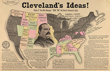
Detail from a political broadside, "The Whole Story in a Nutshell! Harrison's Ideas! Cleveland's Ideas!" from the 1888 presidential campaign, much of which focused on trade policy. Image: Division of Rare and Manuscript Collections.
Mode says his work as a litigator, which convinced him of the power of visual messages, helped spark his interest in persuasive cartography. His fascination with maps began in the summer of 1980, when he wandered into an exhibition of old and unusual maps at the Pompidou Center in Paris -- "Carte et Figures de la Terre." He began collecting one or two maps a year. Now he has more than 700 persuasive maps, and planning is underway to add the remaining maps to Cornell's site.
"PJ Mode's achievement as a collector in this subject is unmatched," says Katherine Reagan, the library's curator of rare books and manuscripts. "We were thrilled by his decision to donate these maps to Cornell and to help us make them freely available to everyone. The resulting digital collection will serve as a valuable resource for students and scholars across multiple disciplines."
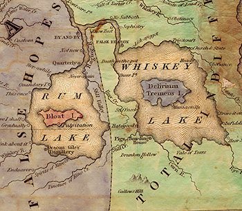
Detail from an early allegorical "map" of temperance, 1838, by Philadelphia minister Rev. John Christian Wiltberger Jr., includes Rum Lake and Whiskey Lake and features provinces of False Hopes and Total Indifference within the Land of Inebriation; to the north (not pictured) is the Land of Self Denial and provinces of Industry, Improvement, Prosperity, Enjoyment and more. Image: Division of Rare and Manuscript Collections.
Mode chose to donate this material to RMC because of his relationship with the university -- his wife, Elaine, is also Class of 1960 -- and the Cornell curators' vision to share the maps digitally and freely. "It was very important to me that users be able to download and use these materials liberally for noncommercial purposes: for teaching, for scholarship or just for fun," Mode says.
The maps' messages cover the full range of human concerns: religious, political, military, commercial, moral and social. For example, the "Imperial Federation Map of the World Showing the Full Extent of the British Empire in 1886" surrounds the continents with elaborate images of the flora, fauna and populations under British control.
"A Map of the Earth and How After the Flood It Was Divided Under the Sons of Noah," from 1681, casts Christian history geographically, with Eden at its center and illustrations of the creation, the expulsion from Paradise, the Tower of Babel and God giving the Ten Commandments to Moses.
The collection, which has been accessed by more than 3,300 users in 98 countries since it went online in August, can be browsed by date or subject, with more than 30 categories including "alcohol," "bias," "politics and government," "slavery," "suffrage" and "communism and Cold War." Each image includes "collector's notes" with historical context.
"They're about skepticism, they're about questioning what you see, questioning what you hear and read. The visual image is a powerful tool, and like all powerful tools, it can be used for good or ill," Mode says. "Part of it is about simply understanding the complexity of the world around you."
Melanie Lefkowitz is staff writer, editor and social media coordinator for Cornell University Library.
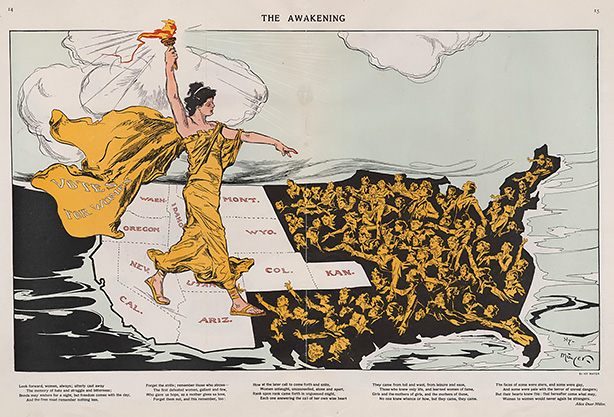
"The Awakening" (1915), by Henry "Hy" Mayer, appeared in the magazine Puck and is one of the suffrage "maps" that played a major role in the fight for women's suffrage in the United States. Lady Liberty, wearing a cape labeled "Votes for Women," stands astride the states (colored white) that had adopted suffrage. She holds aloft her torch, bringing "enlightenment" to women in those states still in the dark. Image: Division of Rare and Manuscript Collections.